The Ridges of Walnut Hills – Under Development for 2026 with Community-Based Contributions
World-Class Disc Golf in the Highlands of Sugarfork, NC

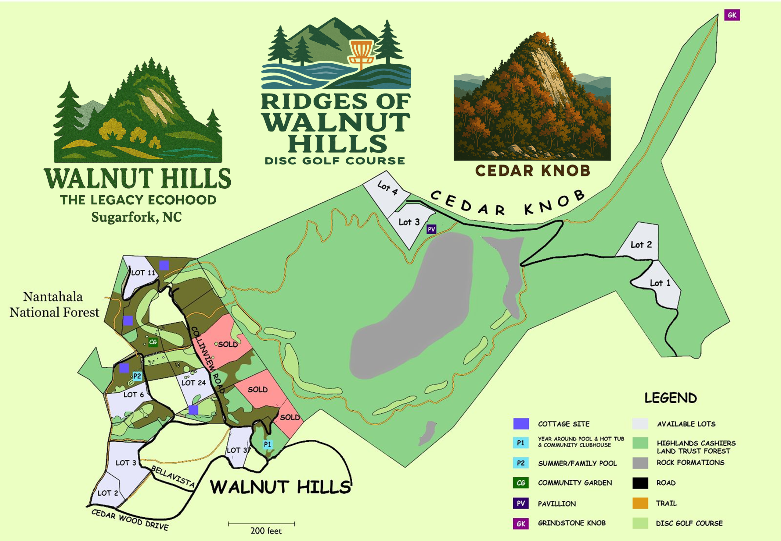
Welcome to The Ridges of Walnut Hills, a private 18-hole disc golf and hiking sanctuary located within the sustainable Walnut Hills community in Macon County. Set across 153 acres of ridgelines, forest, and scenic meadow, the course offers unmatched elevation, beauty, and challenge for those looking to play and stay in a true mountain legacy environment.
The Front 9 – Into Walnut Hills
Flowing through forest paths at around 3,340′, meadow fairways, and serene creekside lanes, the front nine holes are sculpted for rhythm and accessibility. Expect beautiful throw lines, moderate elevation shifts, and nature-integrated play that welcomes beginners while challenging advanced players.
The Back 9 – The 700+ ft Ascent to Cedar Knob
The real adventure begins as you climb over 700 feet in elevation from Walnut Hills’ upper trails to the summit of Cedar Knob at 4,109 feet. With panoramic summit baskets, breathtaking drop zones, and natural terrain challenges, this ascent rivals anything in Southeastern disc golf.
Ganvuta Passage – Trail to Cedar Knob
Rising from 3,390 ft at Upper Walnut Hills to the 4,109 ft summit of Cedar Knob, the Ganvuta Passage is a signature ascent gaining 719 feet in under 1,200 feet of horizontal trail. Shown below are two visual representations of this remarkable climb.
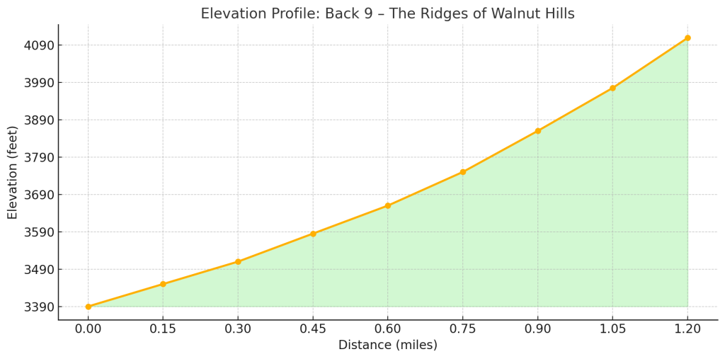
🔹 Elevation Profile (Side View)
This chart shows the trail’s elevation gain across its 1,200-foot span. From a base of 3,390 ft to a summit of 4,109 ft, hikers can expect a steep and consistent incline. Tight curves in the orange line reflect steeper segments, especially near the top.
- X-Axis: Trail length in feet (0–1,200 ft)
- Y-Axis: Elevation gain (3,390–4,109 ft)
- Best for: Trail runners, hikers, and general trail overview
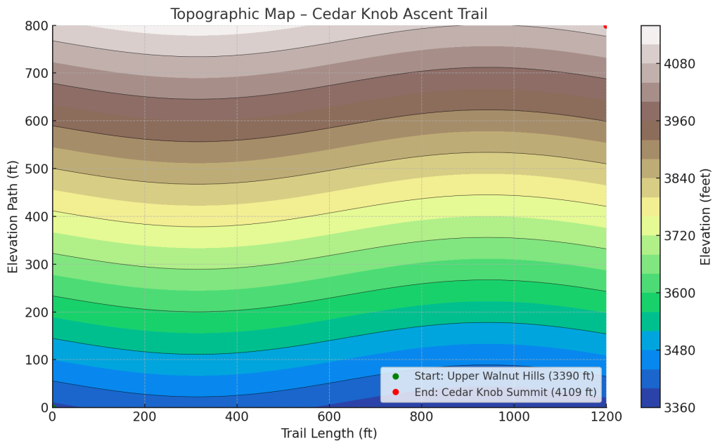
🔹 Typographical Gradient Map (Contour View)
This visual uses color shading to show how steep the terrain is along the Ganvuta Passage. Blue and green areas represent lower elevations, while yellow, brown, and white indicate the steepest climbs near the summit.
- Color Bands: Represent rapid elevation change and slope intensity
- Start Point: 🟢 Upper Walnut Hills – 3,390 ft
- End Point: 🔴 Cedar Knob Summit – 4,109 ft
- Best for: Trail design, ecological study, or dramatic visual storytelling
Access with Purpose
The Ridges is a semi-private course designed with sustainability, community, and quality of experience in mind. Access is prioritized for Walnut Hills property owners, eco-cottage guests, and project backers — ensuring the land remains protected, the trails well-tended, and the experience truly memorable.
While not open for general public play, special events, volunteer days, and local partnerships help ensure that the community still shares in the beauty and mission of the mountain.
Stay. Play. Reconnect.
Planning a visit? Backers of our crowdfunding campaign receive exclusive lodging perks, trail access, and disc golf privileges. Stay in one of our handcrafted cordwood hempcrete eco-cottages and experience the beauty of the mountains from your doorstep.
Learn more and join the campaign here to claim your access pass and start your legacy journey.